Macquarie Island
Explore Macquarie Island with Heritage Expeditions.
Macquarie Island is an Australian Subantarctic Island with an area of 12,875 hectares (31,814 acres). It is 34 kilometres (21 miles) long and up to 5 kilometres (3 miles) wide, and is located 1,500 kilometres (930 miles) south-east of Hobart, Tasmania. This island of the antipodes is a nature reserve managed by the Tasmanian Government through the Parks and Wildlife Service (PWS). The PWS also manages the island as a World Heritage Site on behalf of the Australian Government. The Australian Government Antarctic Division maintains a research station on the island, and the Bureau of Meteorology collects weather data, including upper air soundings. Macquarie Island was declared a Wildlife Sanctuary in 1933, a State Nature Reserve in 1972, and a UNESCO Biosphere Reserve in 1977. It was listed in the Register of Critical Habitat in 2002. The various designations reflect the importance of the reserve and the natural and cultural values it embodies. In 1999 the ocean around Macquarie Island became an Australian Marine Park and has been predator free since the Macquarie Eradication Project in 2011 - 2013.
READ LESS
Geography
Geographical Information: 54º 37’S, 158º 54’E, in the South Pacific Ocean, 1500 kilometres south-east of Tasmania
Area: 12 785 hectares
Maximum Altitude: 433 metres (Mt Hamilton)
Physical Features: Macquarie Island is uniquely formed and part of a 750 miles long ridge created about 600,000 years ago by a rift in the earth’s crust subsequently closing and extruding molten rock right up to the surface. The result could be compared to the squeezing of a toothpaste tube, resulting in molten rock from the earth’s mantle 5 to 6.5 kilometres (3 to 4miles) below the ocean floor rising to become exposed on the surface. It is the only known place on earth where this has occurred, and there has been no previous or subsequent volcanic activity. The island is still rising rapidly. Because of its geology, Macquarie Island was designated a World Heritage Site in 1977.
Macquarie Island probably began as a spreading ridge under the sea with the formation of new oceanic crust somewhere between 11 and 30 million years ago. At some stage the spreading halted and the crust began to compress, squeezing rocks from deep within the mantle upwards like toothpaste from a tube. As the ridge grew it eventually became exposed above the ocean’s surface about 600,000 years ago.
Macquarie Island Ramble
Macquarie has a number of special features. Firstly, there are no other Subantarctic Islands which have been squeezed upwards from the oceanic crust to form an island like this. Most Subantarctic Islands, including Heard Island, initially developed as underwater volcanoes. Some are now exposed above the sea as a result of the accumulation of layers of lava. Prince Edward Island, the McDonald Islands and Iles Crozet also formed from submarine volcanoes, while Auckland and Campbell Islands have volcanic origins but they were previously attached to continents and the continental crust.
Secondly, the rocks of Macquarie Island which are in their original (oceanic) geological setting are far less deformed than similar rocks elsewhere. For example, the Troodus complex of Cyprus, the Semail complex of Iman and the Bay of Islands complex of Newfoundland, although geologically similar to Macquarie Island, are more deformed. These rocks have also been ‘welded’ to continental-type rocks, a process in which the rocks are squashed, stretched or both.
There is still considerable geological debate over whether the rocks in the complexes actually originated from the oceanic crust. Some geologists feel that they have formed in entirely different ways, such as the case of the volcanic islands around the Pacific Rim where oceanic crust is being forced, or subducted, below the adjacent continent. Macquarie Island is in a totally different geological setting to these islands, but is considered to be very close to its original oceanic setting. It has not been forced up against the edge of a continent.
As the geological origin of the island differs from that of other Subantarctic Islands, so does its landscape and the processes shaping it. The major difference is that most of the Macquarie landscape has been formed by marine erosion processes such as wave erosion as it has risen above sea level. In contrast, many of the volcanic islands tend to develop in major explosive events when growth above sea level is very rapid and the only erosive effects occur around the coastal perimeter. It has also been argued that unlike other Subantarctic Islands, whose landscapes have been molded by ice, Macquarie has not been glaciated.
In the last 600 to 700 thousand years, Macquarie has emerged above sea level and recent estimates suggest that since about 6,000 years ago it has been rising at an average rate of about 0.8mm per year. Evidence that the island has risen above the sea surface is provided by numerous old beaches or areas eroded by waves at altitudes ranging from 6 - 400 metres (20 to 1,300 feet). The other large influence on the shape of Macquarie Island has been the extensive faulting which also contributes to earthquake activity. Macquarie Island experiences an earthquake of 7.5 on the Richter scale once every decade. There are many large and active faults which have shaped the coast, created fault-dammed lakes and controlled the location of major landforms. Earthquakes trigger major landslip events, the scars of which cover many slopes.
One of the more intriguing aspects of Macquarie Island is the general lack of creeks and river. Some lakes lack inflowing or outflowing creeks. This appears to be due to the highly fractured nature of the bedrock or the way in which the bedrock dips or slants. This results in water percolating quickly through the rock, perhaps ultimately re-emerging on the shore platform which skirts parts of the island. These lakes are exceedingly boggy. The bogs are composed of peat reported to be up to 6m deep and are thought to have formed over the last 5,000 to 7,000 years. This would suggest a very fast rate of organic accumulation or slow rate of decomposition in comparison to peats in other parts of the world. Rates are never constant, but on average it appears as if the lowland bogs on Macquarie have developed at about 10 times the rate of many other peatland areas in the world.
READ LESS
History
Macquarie Island was one of the earliest European occupied sites in Australia: the first British settlement in Tasmania predates it by only seven years. The occupation of Macquarie Island differed from the early settlements in mainland Australia in that it was intermittent and an initiative of private enterprise rather than of government. Until comparatively recent times, the animal oil and sealskin industries were virtually the only reason for Macquarie’s having a history of human habitation.
It is possible that Polynesians visited or were wrecked on Macquarie Island in the distant past, but the first recorded sighting of the island was on 11 July 1810 by Captain Frederick Hasselborough on the brig Perseverance, out of Sydney on a sealing expedition. He named his discovery Macquarie Island, after Governor Lachlan Macquarie of New South Wales, Australia.
Captain Hasselborough landed a party of eight sealers, it is not known precisely where, with nine months provisions and returned to Sydney for more salt, which was used in the curing of skins and supplies. His men had found the island’s potential for sealing excellent “with sufficiency of skins to employ four to five gangs” and he intended to keep its location secret. He failed. Reportedly he was tricked into revealing the location during a night’s carousing in Sydney and by December 1810 three other parties of sealers had been landed. By that time the location of Macquarie Island had also been published in the Sydney Gazette and the commercial exploitation was under way.
The sealing gangs were quick to establish bases on the island. One early gang, led by a man named Rook, worked from a base at Sandy Bay, another established at the Isthmus and set up tryworks suggesting that oil from elephant seals was also exploited right from the start. A typical early cargo from Macquarie Island, landed in Sydney on May 1811 from the Aurora, consisted of 60 tons of seal oil and 30,000 sealskins.
By 1816 at least four sealing gangs had bases on the island. Underwood maintained two stations, one at North Head and the other at Sandy Bay and in 1820 an operation in Lusitania Bay was run by a man named Raine, from Tasmania.
The exploitation of Macquarie Island fur seals was quickly devastating, the skins were easier to obtain than oil, took up less space in the boats and were more valuable. The original market for fur seal pelts was China, but after 1815 the British developed a tanning method that allowed the coarse outer hairs to be extracted and exposed the second layer of fur beneath. Then Britain became the main market. The pelts were made into various kinds of clothing, including men’s hats.
It has been estimated that there were between 200,000 and 400,000 fur seals on Macquarie Island when sealing began, and in the first 18 months after the island’s discovery at least 120,000 skins were taken. Both the number of fur seals on the island and the consequent ease with which they could be killed are graphically suggested by an entry in the log of the Mary and Sally, which made a sealing voyage to Macquarie Island in 1813. “At 11am the boat was sent to shore to look for seal. At 2pm the boat returned with 256 skins and was hoisted in”.
The effect of such unrelenting slaughter was quickly obvious. As early as 1815 the Sydney Gazette was suggesting that Macquarie Island was no longer profitable for sealers and in 1821, just 10 years after the island’s discovery, only four fur seal skins were obtained in a one-year period. In total as many as 193,000 fur seal skins were taken, according to one scientific estimate, and possibly one species of fur seal was eradicated entirely from the island.
After devastating the fur seal population sealers turned their full attention to elephant seals, whose blubber contained oil that could be used as a fuel for lighting, lubricant for iron machinery and in tanning and rope manufacture. By 1826 the production of elephant seal oil seems to have been the only remaining commercial activity. Scientists have calculated that there were between 93,000 and 110,000 elephant seals on Macquarie Island, a population reduced by 70 per cent within 20 years.
Consequently, between 1830 and 1874 only three sealing ships called at Macquarie Island. One of them, the Lord Nelson was wrecked at Hasselborough Bay’s western end in 1838, with the survivors waiting two years to be rescued. In 1851 the North End was worked where “over one dozen old houses and a great quantity of bones and hoops buried here; there are tri-pots set about in different places; there are two graves on the flat”. There were also several visits from non-sealing ships during this time, but between 1860 and 1873 there were no recorded ship visits to Macquarie Island.
Sealing resumed in 1873 and between then and 1889 some 30 ships visited the island. An 1873 visitor was the Sarah Pile, whose crew slaughtered some seals and introduced the Weka, a flightless bird from New Zealand to the island as a food source. Rabbits were also released on Macquarie Island in the 1870s for the same reason. Feral cats had been recorded on the island as early as 1820 and mice and ship rats by the 1890s. The last cats were eradicated in 2002.
In 1902 a New Zealander named Joseph Hatch, who had begun a sealing operation on the island in 1890 secured exclusive sealing rights to Macquarie Island. His ships made 75 voyages there between 1890 and 1919. He did not take as much oil during his long association with the island as earlier exploiters had done, but his operations left some of the most visible remains there, notably at the Isthmus. He began in 1889 at Lusitania Bay where he landed the first steam digester plant to begin exploiting the King Penguin population. This attempt failed because of the rapid reduction in penguin numbers and difficulties with the oil fermenting due to its high blood content. Subsequently, Hatch moved his Macquarie Island headquarters to The Nuggets and introduced more steam digester plants to exploit the Royal Penguins there. Other plants were later installed at the Isthmus, Hurd Point and Hasselborough Bay.
But even with those technical innovations, Macquarie Island was not always continuously occupied. Hatch’s men did not work the 1901 season, but the following year Hatch was granted a sole occupational license to the island and sealing recommenced.
In the late 19th Century, as seal numbers dwindled on the more accessible beaches, the production of oil from penguins, an industry believed to have been unique to Macquarie Island, became more important than sealing. Penguin oil was not as valuable as seal oil, but it had the advantage that it could be based on a few large colonies. By 1894 the King Penguin colony at Lusitania Bay was so devastated that it ceased to be commercially viable.
The Royal Penguins at The Nuggets then became the focus of the oil industry. At their peak, around 1905, the plant could process 2,000 penguins at one time. Each penguin yielded about half a litre of oil.
Serious activity of a different kind reached Macquarie Island in 1911 with the arrival of Douglas Mawson’s Australasian Antarctic Expedition which found on the island the shipwrecked crew of the Clyde and half a dozen sealers who were prepared to defend their sealing rights against what they thought was an opposition sealing expedition. Mawson loved the island and on his return to Australia he began a campaign to stop oiling and to have it made a wildlife sanctuary. World War One reduced the impetus, but after the war petroleum products were increasingly available for use making inroads into the animal oil market. In 1919 oil production on the island stopped, the following year the Tasmanian Government revoked Hatch’s license and the commercial exploitation of Macquarie Island was over.
In the 109 years there were 207 recorded visits by sealers to Macquarie Island and during the same period several shore stations were established and at least nine ships wrecked on the island. The sealers lives were hard, their housing primitive. A visitor in 1820 described the head man’s hut at Sandy Bay as “20 feet long by 10 feet broad, inside it was lined with skins of seals, the outside was covered with a kind of grass which grows on the island. At one end there was a small hearth and a lamp was always kept alight. Beside the hearth was a bedstead. Provisions were stored at the other end of the hut. Windows were bladder covered holes".
Recent archaeological work has revealed that more remains of sealing gangs’ occupation of Macquarie Island have survived than was expected, landslides having covered and therefore protected a number of sites. Some traces of sealers huts remain and digesters and other artefacts from sealing days have also survived and may be inspected at the Isthmus by visitors. They are, however, comparatively late, dating only from the time of Hatch’s operations (1890-1919). An early tussock peat walled hut thought to date from the 1820’s was recently uncovered at the tryworks site at Hurd Point.
Scientific Visitors
The first scientific investigation of Macquarie Island was the Russian expedition led by Bellinghausen, which visited the island in 1820 and made a small collection of the flora and fauna. Scientific interest in Macquarie Island remained slight for a long time. An American expedition led by Charles Wilkes collected some specimens in 1840, but they were later lost.
The first systematic collections and studies began when J H Scott, Professor of Anatomy and Physiology at the University of Otago, New Zealand spent some days on the island in 1883. Then Augustus Hamilton, later Director of the Colonial Museum in Wellington, New Zealand made a short visit in 1894. He and his son, Harold, a later scientific visitor are commemorated in the name of the island’s highest point, Mt. Hamilton.
Joseph Burton sailed to Macquarie Island on the Gratitude in 1896 and spent three and a half years working on the 'dreadfully dreary' islands with oiling parties and collecting in his spare time.
Expeditions visited Macquarie Island more frequently as Antarctic exploration became more common. Captain Robert Falcon Scott collected a small number of specimens in 1901, a bottle of liqueur had to change hands before the collecting party was allowed to land. Another British polar expedition led by Sir Ernest Shackleton, called at the island in 1909 'for the purpose of making zoological and geological collections and also of observing whether any Antarctic birds or penguins migrated there in the winter months'. Among other things, Shackleton’s landing party found an Irish seaman named William McKibbin, who in 1907 elected to stay on the island alone in the hope of collecting enough oil to enable him to buy a boat. McKibbin refused the expedition’s offer of a passage back to civilization, but arrived at Invercargill, New Zealand on the Hinemoa late the following year.
The first scientific station on the island was established in 1911 by Douglas (later Sir Douglas) Mawson and maintained until 1914, the year Mawson was knighted. It made studies of the island’s botany, zoology, meteorology and geology, as well as magnetic observations and the first detailed maps of the island. The Macquarie Island party also established a radio link between Australia and Mawson’s main group at Commonwealth Bay, the first such radio link with Antarctica. To do so they used a sealers flying fox to haul masts, aerials and timber up the cliff at Aerial Cove and constructed a transmission hut and an engine room and set up an aerial. The party also built a headquarters, George V Villa, at the northern end of the Isthmus below Wireless Hill.
During the years 1913 to 1915 the meterological observations begun by Mawson’s party were continued by the Commonwealth Meterological Expedition under Power (1913-14) and Tullock (1914-15). Sir Ernest Shackleton in the Aurora visited Macquarie Island again in 1917 and in 1930 Mawson aboard Discovery was back with the British, Australian, New Zealand Antarctic Research Expedition.
The first permanent scientific station was established on the island by the Australian Government in 1948. The Australian National Antarctic Research Expedition (ANARE) Station has been operating there ever since.
READ LESS
Flora & Fauna
FLORA:
Coastal Terraces Vegetation
The beach slope/raised coastal terraces of Macquarie Island occupy the region between the coastal zone and the coastal slopes. They support several different vegetation formations, quite different from those found on sandy or stony beaches. Much of the underlying soil consists of peats.
The composition of the vegetation in this area is determined by drainage, the height of the water table and water run off from the coastal slopes and plateau uplands. Animal disturbance may also have an effect on the flora of this region.
In areas of good drainage grow mixed stands of Poa foliosa and Stilbocarpa polaris – the Macquarie Island Cabbage. Poa foliosa is also found bordering the edges of streams that run across the region. In areas where runoff from the coastal slopes accumulates in flush lines, communities of the reed Juncus scheuchzerioides, Montia fontana and the moss Breutelia pendula can be found.
If drainage is not good, or the water table is close to the surface of the soil, a ‘feather bed’ community develops. This community is a quaking-mire and is typically dominated by mosses and liverworts. Pleurophyllum hookeri can also be found growing in these mire communities, often in rows.
Short grassland generally occurs in areas influenced by animals. These areas are dominated by Festuca contracta, occasionally along with Luzula crinita and Agrostis magellanica.
One of the most extensive community types in the raised coastal terraces is herb field. This can occur in a range of varying environmental conditions, but most commonly occurs on well-drained soils where the water table is a little below the soil surface. Major plant species growing in these areas are Poa foliosa, Stilbocarpa polaris and Pleurophyllum hookeri, along with mosses, lichens, liverworts and other small vascular plants.
Animals abound in this region. Areas of Poa foliosa/Stilbocarpa polaris provide refuge for elephant seal pups after weaning and adult seals after moulting. They are also common breeding sites for Northern and Southern Giant Petrels and Gentoo Penguins. This area is also an important habitat for introduced mice, rats and rabbits.
Trampling and destruction of vegetation by animals like elephant seals, and increased nutrient levels owing to bird and mammal defecation and urination can cause significant local changes to the vegetation, as can rabbit grazing, causing some areas to be converted to short grassland. Bird, mouse, rat and rabbit burrowing has an effect as well.
Stilbocarpa polaris, the Macquarie Island Cabbage, is one of only two plants on the island to have conspicuous flowerheads (the other is Pleurophyllum hookeri), and can grow up to a metre in height. The cabbage only occasionally grows from seed (mice and rats eat large quantities of its seed) and more often regenerates from a tough, underground rhizome. The plant was used by early inhabitants of the island, including sealers, expeditioners and scientists as a vitamin C source. The stems, leaves and rhizomes of the plant can all be consumed by humans.
Coastal Zone Vegetation
The coastal zone communities on Macquarie Island are part of an active shoreline, constantly battered by waves and strong winds. Storms are common and sea spray ensures a steady deposition of salt, which is partly offset by the frequent light rain. These communities extend from the water’s edge to above the extreme high water mark. The two main coastal zone communities are those on rocky shorelines and those on beaches of sand, gravel or cobbles.
In a typical coastal zone community on rocky shorelines, beds of kelp and marine algae are found in the intertidal areas, forming an algal zone. Above the high water mark, a lichen-dominated zone exists. During stormy weather this area is subject to inundation by the sea. The lichens Verrucaria, Xanthoria, Turgidosculum (Mastodia), Lecanora and the moss Muelleriella crassifolia are typically found in this area. Above this lichen-dominated zone, moss and lichen species mix with tufts of the grass Puccinellia macquariensis and cushions of Colobanthus muscoides. During exceptionally stormy weather this zone may also be affected by waves.
Sandy and gravel beaches generally do not support any vegetation. Several vascular plants grow above the high water mark on cobble beaches, principally Cotula plumosa, Poa annua and Callitriche antarctica. The rocks may also support a number of crustable lichen species. Well above the high water mark, the beaches are covered by a tall tussock grassland of Poa foliosa. These tussocks may reach heights of 2m or more.
Rock stacks often rise above the shoreline or the water itself. These stacks are usually capped by grass tussocks and other vegetation, which provide nesting sites for birds, rats, mice and rabbits.
The composition and structure of coastal zone communities is determined by several factors: the topography of the coast, which determines the extent to which the shoreline is exposed to waves and wind; whether a beach is present, and its structure; and the surrounding vegetation composition and amount of animal disturbance present.
The most notable impacts are caused by the 3 to 4 million animals, principally birds and seals, which populate this region at various times of the year. After weaning, elephant seal pups often retreat from the exposed beach to the shelter of the tussock grass communities. Moulting seals use tussock communities for shelter and to rub off their peeling skin. Consequently many tussocks are damaged by seals as they lie, trample, and rub themselves against them. Fur seals prefer rocky areas as haul out sites. Penguin colonies (and seals to a lesser extent) dramatically influence nutrient levels in the areas they inhabit, due to the effects of their dung and urination. One tussock grass, Poa cookii, is found mainly close to penguin colonies and may either tolerate or require more nutrients.
The Plateau Uplands
The plateau uplands are the most extensive zone on Macquarie Island, sitting atop the island and running its entire length. A broad range of plant communities can be found there. These are tall tussock grassland, short grassland, herb fields, mire in sheltered sites, and feldmark in exposed areas.
Composition and structure of the plant communities of the plateau uplands is determined by exposure to wind, drainage and soil depth. In addition, animal disturbance may have a modifying effect on the vegetation.
Tall tussock grassland dominated by Poa foliosa can be found in sheltered and relatively exposed situations on the plateau. The tussocks are smaller than those found at lower altitudes and often form a low sward rather than tussock.
Short grassland communities dominated by Festuca contracta or Agrostis magellanica and Luzula crinita are quite widespread.
Three types of herb field are present in the region. Those dominated by Acaena sp. are primarily determined by the influence of rabbit grazing; the fur of rabbits and the feathers of burrow-nesting birds assist in dispersing the hooked seeds. Those dominated by Pleurophyllum hookeri and Stilbocarpa polaris grow on gully sides and in sheltered, well-drained sites. Communities dominated by the cushion-forming Azorella macquariensis and by Pleurophyllum hookeri are relatively widespread in sheltered feldmark sites.
If the water table is high and drainage is poor, a mire community may form. Typical plant species occurring in mires in the plateau uplands are Agrostis magellanica, Ranunculus biternatus, Juncus scheuchzeroides and the mosses Breutelia pendula and Bryum laevigatum.
The most extensive plant community occurring in the plateau uplands is the feldmark community, which occupies 45 percent of the island’s surface. Feldmark vegetation on Macquarie Island is comprised of dwarf flowering plants, mosses, lichens, liverworts and a significant amount of bare ground. The dominant vascular plant is the cushion plant Azorella macquariensis. Feldmark communities often form into patterns of alternating stripes of vegetation and bare ground, particularly on windward slopes. This striping effect is sometimes associated with terracing, particularly on leeward or sheltered slopes.
The main factors which impact this region are wind exposure and frost action in the soil. This area is typically considered to be the windiest on the island. Upland grasslands are also an important habitat for burrow-nesting petrels, rabbits and mice, each of which has an effect on the area.
Terraces are a component of the upland feldmark vegetation on Macquarie Island. Terraces are alternating bands of vegetation and gravel in a step/stair arrangement. They occur on slopes and tend to be more common on the eastern side of the island, in the lee of the prevailing winds. The vegetation forms the riser and the gravel the flat tread of the terraces. On windward terraced slopes, this trend is reversed. This is most likely due to the fact that the terraces on the windward (western) side of the island are wind formed, whereas those on the leeward (eastern) side of the island are formed by solifluction processes, which is the movement of soil due to the action of ice forming and pushing soil down-slope.
FAUNA:

Macquarie Island Shag
The highlight of a visit to Macquarie Island has to be the endemic Royal Penguin and the Macquarie Island Shag, but time spent with the King, Gentoo and Rockhopper Penguins is also time well spent.
Macquarie Island is home to over 200,000 pairs of King Penguins and an estimated 3,000,000 Royal Penguins. In addition, there are Rockhopper and Gentoo Penguins and albatross including Wandering, Black-Browed, Grey-Headed and Light-mantled Sooty Albatross.
The island is a breeding ground for elephant seals. In the past, the fur seals here were virtually eliminated through harvesting. Oil rendering of elephant seals and Royal Penguins reduced their numbers to the point where the venture was no longer profitable.
The indigenous fur seal, species unknown, was virtually exterminated within 10 years of the island being discovered. The remaining indigenous mammals are all marine, comprising whales and seals, and include Southern Right Whale, Balaena glacialis, rare sightings of Sperm Whale, Physeter macrocephalus, Orca Orcinus orca, the most common whale observed at Macquarie Island, and the Long-finned Pilot Whale Globicephala melaena. Other positive whale records include the Southern Bottlenose Whale Hyperoodon planifrons and Cuvier’s Beaked Whale Ziphius cavirostris.
The Southern Elephant Seal Mirounga leonina population at Macquarie Island numbered 110,000 during the mid-1950s (Carrick and Ingham, 1962). New Zealand Fur Seal Arctocephalus forsteri, Subantarctic Fur Seal A. tropicalis and Antarctic fur seal A. gazella are also found. New Zealand (Hooker’s) Sea Lion Phocarctos hookeri and Leopard Seal Hydrurga leptonyx visit each winter and spring. Weddell Seal Leptonychotes weddelli and Crabeater Seal Lobodon carcinophagus are very rare visitors from the south.
Southern Elephant Seal
The Southern Elephant Seal, Mirounga leonina, is one of two species of elephant seal. It is not only the most massive pinniped, but also the largest member of the order Carnivora to ever have lived. The seal gets its name from its great size and the large proboscis of the adult males, which is used to make extraordinarily loud roaring noises, especially during the mating season.
There is a great sexual dimorphism in size, with the males being much larger than the females. While the females average about 680 kilograms (1,500 pounds) and 3 metres (10 feet) long, the bulls grow to around 3,600 kilograms (8,000 pounds) and 6.3 metres (21 feet) long. The record bull, shot in Possession Bay, South Georgia in 1913, was 5,000 kilograms (11,000 pounds) and 6.9 metres (22½ feet) long.
Southern Elephant Seals are primarily found in Antarctica and other Subantarctic Islands near the Arctic Polar Front. South Georgia is home to the largest of these populations, this one being more than half the entire species’ population. Significant populations are found at Macquarie Island, Heard Island, and the Kerguelen Islands. Some births have been reported in New Zealand, Australia and South Africa. Wandering individuals have been seen as far north as the equator. These seals were heavily exploited during the 19th and early 20th centuries by sealers after their oil. Their numbers have since recovered and now it is not uncommon for them to be seen in Southern Oceanic regions. The population size of Southern Elephant Seals is estimated to be roughly 600,000 individuals.
Elephant seals feed in deep water and can dive to great depths – up to 1,700 metres (5,577 feet). Dives lasting up to two hours have been recorded. They feed on cephalopods such as squid and cuttlefish, and on large fish including small deep-water sharks. When at sea, they spend a high proportion of their time underwater, and they only need to spend a few minutes on the surface between dives. The elephant seal’s only significant predator is the Orca.
After their near extinction due to hunting in the 19th century and subsequent recovery, the populations now standing at roughly 600,000 seems to be declining. The reasons for this are unclear, but it may simply be that once protection from hunting was established, the species recovered so fast that it overshot its equilibrium numbers. Most of the Southern Elephant Seal’s important breeding sites are now protected by international treaty, as UNESCO World Heritage Sites, or by national legislation.
Southern Elephant Seals breed from August to November. The bulls arrive many weeks before the females do and claim territories through loud roars, body positions, and combat fighting. Like its cousin the Northern Elephant Seal, this species is highly polygynous, and the most successful (alpha) males can have harems of up to 60 females. Beta males are also present and have smaller harems. The least successful males have no harems, but will go so far as to try to seduce an alpha or beta male’s females when the male is not looking. An elephant seal must stay in his territory to defend it, which could mean months without eating and having to live on its accumulated blubber.
Southern Elephant Seal pups are born up to 10 days after the females come to shore and are nursed for up to 23 days. After that, the pups are left to fend for themselves while the females mate with the harem’s male to produce a new pup. The weaned pup may leave the beach and teach itself how to feed. Overcrowded beaches are dangerous for pups, as they are often crushed to death.
Leopard Seal
The Leopard Seal, Hydrurga leptonyx, is the second-largest species of seal in the Antarctic, after the Southern Elephant Seal, and is near the top of the Antarctic food chain. It is most common in the Southern Hemisphere along the coast of Antarctica and on most Subantarctic Islands. Along with all of the other earless seals, the Leopard Seal belongs to the family Phocidae, and is the only species in the genus Hydrurga.
The Leopard Seal is large and muscular, with a dark grey back and light grey on its stomach. Its throat is whitish with the black spots that give the seal its common name. Females are generally larger than the males. The bulls are 2.5 metres (8.2 feet) to 3.2 metres (10½ feet) in length and weigh between 200 kilograms (441 pounds) and 453.5 kilograms (1,000 pounds), while cows are between 2.4 metres (7.9 feet) and 3.4 metres (11.2 feet) in length and weigh between 225 kilograms (495 pounds) and 591 kilograms (1,303 pounds). It can live for 26 years, possibly more. Orcas are the only natural predators.
Compared to most phocids, the Leopard Seal is highly evolved for its role as keystone predator. Although it is a true seal and swims with its hind limbs, it has powerful and highly developed forelimbs similar to those of sea lions, giving it a similar manoeuvrability – a classic example of convergent evolution. Like these eared seals, the Leopard Seal is a shallow water hunter and does not dive deep like the other seals of the Antarctic (the Weddell Seal, the Ross Seal and the two species of elephant seal) which can all dive to several hundred metres in search of squid. The Leopard Seal has an unusually loose jaw that can open more than 160 degrees, allowing it to bite larger prey.
The Leopard Seal lives in the cold waters surrounding Antarctica. During the summer months, it hunts among the pack ice surrounding the continent, spending almost all of its time in the water. In the winter, it ranges north to the Subantarctic Islands. Occasionally, individuals may be spotted on the southern coasts of South America, Australia, and New Zealand, and as far north as the Cook Islands. Juveniles are more often found in the north.
The Leopard Seal is a solitary creature. They come together in small groups only when it is time to mate. The female digs a hole in the ice and, after a nine-month gestation period, gives birth to a single pup during the Antarctic summer. She protects the pup until it is able to fend for itself.
The Leopard Seal is bold, powerful and curious. In the water, there is a fine line between curiosity and predatory behaviour, and it may ‘play’ with penguins that it does not intend to eat. It has canine teeth 2.5 centimetres (1 inch) long and feeds on a wide variety of creatures. Smaller seals probably eat krill for the most part, but also squid and fish. Larger Leopard Seals probably switch to feeding on King and Emperor Penguins, and, less frequently, other seals such as the Crabeater Seal. Its senses of eyesight and smell are highly developed. These senses, coupled with a streamlined body that enables the seal to move swiftly through the water, ensures that it is a formidable predator.
When hunting penguins, the Leopard Seal patrols the waters near the edges of the ice, almost completely submerged, waiting for birds to enter the ocean. It kills the swimming bird by grabbing its feet, then shaking the penguin vigorously and beating its body against the surface of the water repeatedly until the penguin is dead. Previous reports stating that the leopard seal skins its prey prior to feeding have been found to be incorrect. Lacking the teeth necessary to slice its prey into manageable pieces, it shakes its prey from side to side in order to tear and rip it into smaller pieces.
In 2003, a Leopard Seal dragged a snorkelling biologist underwater to her death in what was identified as the first known human fatality from a Leopard Seal. However, numerous examples of aggressive behaviour, stalking, and attacks on humans had been previously documented. The Leopard Seal has previously shown a particular predilection for attacking the black, torpedo-shaped pontoons of rigid inflatable boats, necessitating the outfitting of research craft with special protective guards to prevent them from being punctured.
King Penguin
The King Penguin, Aptenodytes patagonicus, is the second-largest species of penguin at about 90 centimetres (3 feet) tall and 11 to 16 kilograms (24 to 35 pounds) in weight, second only to the Emperor Penguin. There are two subspecies – A. p. patagonicus and A. p. halli. Patagonicus is found in the South Atlantic, and halli is found elsewhere.
King Penguins eat small fish – mainly lanternfish – and squid, and rely less than most Southern Ocean predators on krill and other crustaceans. On foraging trips, they repeatedly dive to over 100 metres (350 feet), often over 200 metres (700 feet). This is far deeper than penguins other than their closest relative, the larger Emperor Penguin.
Like all penguin species, the King Penguin has a streamlined body which minimises drag while swimming, and wings that have become stiff, flat flippers. There is little difference in plumage between the male and female, although the latter are slightly smaller. The upper parts are steel blue-grey, darkening to black on the head, sharply delineated from the pale underparts; the belly has white to orange colouring on the upper breast with bright orange ear patches. The 12 to 13 centimetre long (4¾ to 5 inch) black bill is long and slender, and curved downwards. The lower mandible bears a striking pink or orange-coloured mandibular plate.
An immature King Penguin will have yellow rather than orange-tinged markings, and grey tips to its black-brown feathers. It moults into adult plumage aft.er reaching two years of age. The chick is first covered with brown-grey down before moulting into a thick, woolly brown coat borne until around 10 to 12 months of age. Their mandibular plates are black until they moult into immature plumage.
King Penguins have adapted well to the extreme living conditions of the Subantarctic. The Penguins have four layers of feathering to keep them warm. The outer layers of feathers are oiled and waterproof, not unlike the feathering of a duck. The inner three layers are down feathers; very effective insulation. A chick is born without the oily outer layer, and therefore cannot fish until maturity. Like most penguins, the King Penguin is able to drink salt water because of its supraorbital gland which filters excess salt from the bloodstream by way of a capillary just above the penguin’s eyes. The excess salt is then expelled through the penguin’s nose in the form of salty brine.
On Macquarie Island, King Penguins are generally only successful at reproducing one year in two, or two years in three in a triennial pattern. The reproductive cycle runs from September to November, as birds return to colonies for a prenuptial moult. Those that were unsuccessful in breeding the previous season will often arrive earlier. They then return to the sea for three weeks before coming ashore in November or December. The female Penguin lays one pyriform (pear-shaped) white egg weighing 300 grams (10½ pounds). It is initially soft and whitish, but hardens and darkens to a pale greenish colour. It measures around 10 x 7 centimetres (4 x 3 inches). The egg is incubated for around 55 days with both birds sharing incubation in shift of 6-18 days each. Hatching may take up to two to three days to complete, and chicks are born semi-altricial and nidicolous. In other words, they have only a thin covering of down and are entirely dependent on their parents for food and warmth. The young chick is brooded in what is called the guard phase, spending its time balanced on its parents’ feet and sheltered by its pouch. During this time, the parents alternate every three to seven days, with one incubating while the other forages. This period lasts for 30 to 40 days before the chicks form crèches – a group of many chicks together. A penguin can leave its chick at a crèche while it fishes, as a few adult penguins stay behind to look after them. Other varieties of penguins also practice this method of communal care for offspring.
By April the chicks are almost fully grown, but lose weight in fasting over the winter months, gaining it again during spring beginning in September. Fledging then takes place in late spring/early summer.
Royal Penguin
The Royal Penguin, Eudyptes schlegeli, inhabits the waters surrounding Antarctica. Royals look very much like Macaroni Penguins, but have a white face and chin instead of the Macaronis’ black visage. They are about 70 centimetres (28 inches) long and weigh about 6 kilograms (13 pounds). Royal Penguins breed only on Macquarie Island and, like other penguins, spend much of their time at sea, where they are assumed to be pelagic.
There is some controversy over whether Royal Penguins are a sub-species of Macaroni Penguins. Individuals of the two groups have been known to interbreed, though this is a relatively rare occurrence.
Krill, fish and small amounts of squid make up the Royal Penguin’s diet. The breeding season begins in September with laying starting in October. It builds its nest by making a shallow hole in the sand or in a weeded area and putting plants and stones inside the nest. Two eggs are most often laid, however only one survives. The egg is kept warm by both parents for 35 days. This is done by rotating 12 day shifts. After hatching, the male watches out for the chick for 10 to 20 days and the female brings food for both of them. Around 20 days, the chick will form a home for warmth and safety. The parents continue to feed it two to three times a day. When the chick is about 65 days old it will have its adult feathers and goes off on its own.
Royal Penguins are not considered threatened; historically they were harvested for their oil. Between 1870 and 1919 the government of Tasmania issuing licences for hunting them, with an average 150,000 penguins (both Royal and King) being taken each year. Since the end of penguin hunting on Macquarie, the numbers have climbed to 850,000 pairs.
FLORA:
Coastal Terraces Vegetation
The beach slope/raised coastal terraces of Macquarie Island occupy the region between the coastal zone and the coastal slopes. They support several different vegetation formations, quite different from those found on sandy or stony beaches. Much of the underlying soil consists of peats.
The composition of the vegetation in this area is determined by drainage, the height of the water table and water run off from the coastal slopes and plateau uplands. Animal disturbance may also have an effect on the flora of this region.
In areas of good drainage grow mixed stands of Poa foliosa and Stilbocarpa polaris – the Macquarie Island Cabbage. Poa foliosa is also found bordering the edges of streams that run across the region. In areas where runoff from the coastal slopes accumulates in flush lines, communities of the reed Juncus scheuchzerioides, Montia fontana and the moss Breutelia pendula can be found.
If drainage is not good, or the water table is close to the surface of the soil, a ‘feather bed’ community develops. This community is a quaking-mire and is typically dominated by mosses and liverworts. Pleurophyllum hookeri can also be found growing in these mire communities, often in rows.
Short grassland generally occurs in areas influenced by animals. These areas are dominated by Festuca contracta, occasionally along with Luzula crinita and Agrostis magellanica.
One of the most extensive community types in the raised coastal terraces is herb field. This can occur in a range of varying environmental conditions, but most commonly occurs on well-drained soils where the water table is a little below the soil surface. Major plant species growing in these areas are Poa foliosa, Stilbocarpa polaris and Pleurophyllum hookeri, along with mosses, lichens, liverworts and other small vascular plants.
Animals abound in this region. Areas of Poa foliosa/Stilbocarpa polaris provide refuge for elephant seal pups after weaning and adult seals after moulting. They are also common breeding sites for Northern and Southern Giant Petrels and Gentoo Penguins. This area is also an important habitat for introduced mice, rats and rabbits.
Trampling and destruction of vegetation by animals like elephant seals, and increased nutrient levels owing to bird and mammal defecation and urination can cause significant local changes to the vegetation, as can rabbit grazing, causing some areas to be converted to short grassland. Bird, mouse, rat and rabbit burrowing has an effect as well.
Stilbocarpa polaris, the Macquarie Island Cabbage, is one of only two plants on the island to have conspicuous flowerheads (the other is Pleurophyllum hookeri), and can grow up to a metre in height. The cabbage only occasionally grows from seed (mice and rats eat large quantities of its seed) and more often regenerates from a tough, underground rhizome. The plant was used by early inhabitants of the island, including sealers, expeditioners and scientists as a vitamin C source. The stems, leaves and rhizomes of the plant can all be consumed by humans.
Coastal Zone Vegetation
The coastal zone communities on Macquarie Island are part of an active shoreline, constantly battered by waves and strong winds. Storms are common and sea spray ensures a steady deposition of salt, which is partly offset by the frequent light rain. These communities extend from the water’s edge to above the extreme high water mark. The two main coastal zone communities are those on rocky shorelines and those on beaches of sand, gravel or cobbles.
In a typical coastal zone community on rocky shorelines, beds of kelp and marine algae are found in the intertidal areas, forming an algal zone. Above the high water mark, a lichen-dominated zone exists. During stormy weather this area is subject to inundation by the sea. The lichens Verrucaria, Xanthoria, Turgidosculum (Mastodia), Lecanora and the moss Muelleriella crassifolia are typically found in this area. Above this lichen-dominated zone, moss and lichen species mix with tufts of the grass Puccinellia macquariensis and cushions of Colobanthus muscoides. During exceptionally stormy weather this zone may also be affected by waves.
Sandy and gravel beaches generally do not support any vegetation. Several vascular plants grow above the high water mark on cobble beaches, principally Cotula plumosa, Poa annua and Callitriche antarctica. The rocks may also support a number of crustable lichen species. Well above the high water mark, the beaches are covered by a tall tussock grassland of Poa foliosa. These tussocks may reach heights of 2m or more.
Rock stacks often rise above the shoreline or the water itself. These stacks are usually capped by grass tussocks and other vegetation, which provide nesting sites for birds, rats, mice and rabbits.
The composition and structure of coastal zone communities is determined by several factors: the topography of the coast, which determines the extent to which the shoreline is exposed to waves and wind; whether a beach is present, and its structure; and the surrounding vegetation composition and amount of animal disturbance present.
The most notable impacts are caused by the 3 to 4 million animals, principally birds and seals, which populate this region at various times of the year. After weaning, elephant seal pups often retreat from the exposed beach to the shelter of the tussock grass communities. Moulting seals use tussock communities for shelter and to rub off their peeling skin. Consequently many tussocks are damaged by seals as they lie, trample, and rub themselves against them. Fur seals prefer rocky areas as haul out sites. Penguin colonies (and seals to a lesser extent) dramatically influence nutrient levels in the areas they inhabit, due to the effects of their dung and urination. One tussock grass, Poa cookii, is found mainly close to penguin colonies and may either tolerate or require more nutrients.
The Plateau Uplands
The plateau uplands are the most extensive zone on Macquarie Island, sitting atop the island and running its entire length. A broad range of plant communities can be found there. These are tall tussock grassland, short grassland, herb fields, mire in sheltered sites, and feldmark in exposed areas.
Composition and structure of the plant communities of the plateau uplands is determined by exposure to wind, drainage and soil depth. In addition, animal disturbance may have a modifying effect on the vegetation.
Tall tussock grassland dominated by Poa foliosa can be found in sheltered and relatively exposed situations on the plateau. The tussocks are smaller than those found at lower altitudes and often form a low sward rather than tussock.
Short grassland communities dominated by Festuca contracta or Agrostis magellanica and Luzula crinita are quite widespread.
Three types of herb field are present in the region. Those dominated by Acaena sp. are primarily determined by the influence of rabbit grazing; the fur of rabbits and the feathers of burrow-nesting birds assist in dispersing the hooked seeds. Those dominated by Pleurophyllum hookeri and Stilbocarpa polaris grow on gully sides and in sheltered, well-drained sites. Communities dominated by the cushion-forming Azorella macquariensis and by Pleurophyllum hookeri are relatively widespread in sheltered feldmark sites.
If the water table is high and drainage is poor, a mire community may form. Typical plant species occurring in mires in the plateau uplands are Agrostis magellanica, Ranunculus biternatus, Juncus scheuchzeroides and the mosses Breutelia pendula and Bryum laevigatum.
The most extensive plant community occurring in the plateau uplands is the feldmark community, which occupies 45 percent of the island’s surface. Feldmark vegetation on Macquarie Island is comprised of dwarf flowering plants, mosses, lichens, liverworts and a significant amount of bare ground. The dominant vascular plant is the cushion plant Azorella macquariensis. Feldmark communities often form into patterns of alternating stripes of vegetation and bare ground, particularly on windward slopes. This striping effect is sometimes associated with terracing, particularly on leeward or sheltered slopes.
The main factors which impact this region are wind exposure and frost action in the soil. This area is typically considered to be the windiest on the island. Upland grasslands are also an important habitat for burrow-nesting petrels, rabbits and mice, each of which has an effect on the area.
Terraces are a component of the upland feldmark vegetation on Macquarie Island. Terraces are alternating bands of vegetation and gravel in a step/stair arrangement. They occur on slopes and tend to be more common on the eastern side of the island, in the lee of the prevailing winds. The vegetation forms the riser and the gravel the flat tread of the terraces. On windward terraced slopes, this trend is reversed. This is most likely due to the fact that the terraces on the windward (western) side of the island are wind formed, whereas those on the leeward (eastern) side of the island are formed by solifluction processes, which is the movement of soil due to the action of ice forming and pushing soil down-slope.
FAUNA:
Macquarie Island Shag
The highlight of a visit to Macquarie Island has to be the endemic Royal Penguin and the Macquarie Island Shag, but time spent with the King, Gentoo and Rockhopper Penguins is also time well spent.
Macquarie Island is home to over 200,000 pairs of King Penguins and an estimated 3,000,000 Royal Penguins. In addition, there are Rockhopper and Gentoo Penguins and albatross including Wandering, Black-Browed, Grey-Headed and Light-mantled Sooty Albatross.
The island is a breeding ground for elephant seals. In the past, the fur seals here were virtually eliminated through harvesting. Oil rendering of elephant seals and Royal Penguins reduced their numbers to the point where the venture was no longer profitable.
The indigenous fur seal, species unknown, was virtually exterminated within 10 years of the island being discovered. The remaining indigenous mammals are all marine, comprising whales and seals, and include Southern Right Whale, Balaena glacialis, rare sightings of Sperm Whale, Physeter macrocephalus, Orca Orcinus orca, the most common whale observed at Macquarie Island, and the Long-finned Pilot Whale Globicephala melaena. Other positive whale records include the Southern Bottlenose Whale Hyperoodon planifrons and Cuvier’s Beaked Whale Ziphius cavirostris.
The Southern Elephant Seal Mirounga leonina population at Macquarie Island numbered 110,000 during the mid-1950s (Carrick and Ingham, 1962). New Zealand Fur Seal Arctocephalus forsteri, Subantarctic Fur Seal A. tropicalis and Antarctic fur seal A. gazella are also found. New Zealand (Hooker’s) Sea Lion Phocarctos hookeri and Leopard Seal Hydrurga leptonyx visit each winter and spring. Weddell Seal Leptonychotes weddelli and Crabeater Seal Lobodon carcinophagus are very rare visitors from the south.
Southern Elephant Seal
The Southern Elephant Seal, Mirounga leonina, is one of two species of elephant seal. It is not only the most massive pinniped, but also the largest member of the order Carnivora to ever have lived. The seal gets its name from its great size and the large proboscis of the adult males, which is used to make extraordinarily loud roaring noises, especially during the mating season.
There is a great sexual dimorphism in size, with the males being much larger than the females. While the females average about 680 kilograms (1,500 pounds) and 3 metres (10 feet) long, the bulls grow to around 3,600 kilograms (8,000 pounds) and 6.3 metres (21 feet) long. The record bull, shot in Possession Bay, South Georgia in 1913, was 5,000 kilograms (11,000 pounds) and 6.9 metres (22½ feet) long.
Southern Elephant Seals are primarily found in Antarctica and other Subantarctic Islands near the Arctic Polar Front. South Georgia is home to the largest of these populations, this one being more than half the entire species’ population. Significant populations are found at Macquarie Island, Heard Island, and the Kerguelen Islands. Some births have been reported in New Zealand, Australia and South Africa. Wandering individuals have been seen as far north as the equator. These seals were heavily exploited during the 19th and early 20th centuries by sealers after their oil. Their numbers have since recovered and now it is not uncommon for them to be seen in Southern Oceanic regions. The population size of Southern Elephant Seals is estimated to be roughly 600,000 individuals.
Elephant seals feed in deep water and can dive to great depths – up to 1,700 metres (5,577 feet). Dives lasting up to two hours have been recorded. They feed on cephalopods such as squid and cuttlefish, and on large fish including small deep-water sharks. When at sea, they spend a high proportion of their time underwater, and they only need to spend a few minutes on the surface between dives. The elephant seal’s only significant predator is the Orca.
After their near extinction due to hunting in the 19th century and subsequent recovery, the populations now standing at roughly 600,000 seems to be declining. The reasons for this are unclear, but it may simply be that once protection from hunting was established, the species recovered so fast that it overshot its equilibrium numbers. Most of the Southern Elephant Seal’s important breeding sites are now protected by international treaty, as UNESCO World Heritage Sites, or by national legislation.
Southern Elephant Seals breed from August to November. The bulls arrive many weeks before the females do and claim territories through loud roars, body positions, and combat fighting. Like its cousin the Northern Elephant Seal, this species is highly polygynous, and the most successful (alpha) males can have harems of up to 60 females. Beta males are also present and have smaller harems. The least successful males have no harems, but will go so far as to try to seduce an alpha or beta male’s females when the male is not looking. An elephant seal must stay in his territory to defend it, which could mean months without eating and having to live on its accumulated blubber.
Southern Elephant Seal pups are born up to 10 days after the females come to shore and are nursed for up to 23 days. After that, the pups are left to fend for themselves while the females mate with the harem’s male to produce a new pup. The weaned pup may leave the beach and teach itself how to feed. Overcrowded beaches are dangerous for pups, as they are often crushed to death.
Leopard Seal
The Leopard Seal, Hydrurga leptonyx, is the second-largest species of seal in the Antarctic, after the Southern Elephant Seal, and is near the top of the Antarctic food chain. It is most common in the Southern Hemisphere along the coast of Antarctica and on most Subantarctic Islands. Along with all of the other earless seals, the Leopard Seal belongs to the family Phocidae, and is the only species in the genus Hydrurga.
The Leopard Seal is large and muscular, with a dark grey back and light grey on its stomach. Its throat is whitish with the black spots that give the seal its common name. Females are generally larger than the males. The bulls are 2.5 metres (8.2 feet) to 3.2 metres (10½ feet) in length and weigh between 200 kilograms (441 pounds) and 453.5 kilograms (1,000 pounds), while cows are between 2.4 metres (7.9 feet) and 3.4 metres (11.2 feet) in length and weigh between 225 kilograms (495 pounds) and 591 kilograms (1,303 pounds). It can live for 26 years, possibly more. Orcas are the only natural predators.
Compared to most phocids, the Leopard Seal is highly evolved for its role as keystone predator. Although it is a true seal and swims with its hind limbs, it has powerful and highly developed forelimbs similar to those of sea lions, giving it a similar manoeuvrability – a classic example of convergent evolution. Like these eared seals, the Leopard Seal is a shallow water hunter and does not dive deep like the other seals of the Antarctic (the Weddell Seal, the Ross Seal and the two species of elephant seal) which can all dive to several hundred metres in search of squid. The Leopard Seal has an unusually loose jaw that can open more than 160 degrees, allowing it to bite larger prey.
The Leopard Seal lives in the cold waters surrounding Antarctica. During the summer months, it hunts among the pack ice surrounding the continent, spending almost all of its time in the water. In the winter, it ranges north to the Subantarctic Islands. Occasionally, individuals may be spotted on the southern coasts of South America, Australia, and New Zealand, and as far north as the Cook Islands. Juveniles are more often found in the north.
The Leopard Seal is a solitary creature. They come together in small groups only when it is time to mate. The female digs a hole in the ice and, after a nine-month gestation period, gives birth to a single pup during the Antarctic summer. She protects the pup until it is able to fend for itself.
The Leopard Seal is bold, powerful and curious. In the water, there is a fine line between curiosity and predatory behaviour, and it may ‘play’ with penguins that it does not intend to eat. It has canine teeth 2.5 centimetres (1 inch) long and feeds on a wide variety of creatures. Smaller seals probably eat krill for the most part, but also squid and fish. Larger Leopard Seals probably switch to feeding on King and Emperor Penguins, and, less frequently, other seals such as the Crabeater Seal. Its senses of eyesight and smell are highly developed. These senses, coupled with a streamlined body that enables the seal to move swiftly through the water, ensures that it is a formidable predator.
When hunting penguins, the Leopard Seal patrols the waters near the edges of the ice, almost completely submerged, waiting for birds to enter the ocean. It kills the swimming bird by grabbing its feet, then shaking the penguin vigorously and beating its body against the surface of the water repeatedly until the penguin is dead. Previous reports stating that the leopard seal skins its prey prior to feeding have been found to be incorrect. Lacking the teeth necessary to slice its prey into manageable pieces, it shakes its prey from side to side in order to tear and rip it into smaller pieces.
In 2003, a Leopard Seal dragged a snorkelling biologist underwater to her death in what was identified as the first known human fatality from a Leopard Seal. However, numerous examples of aggressive behaviour, stalking, and attacks on humans had been previously documented. The Leopard Seal has previously shown a particular predilection for attacking the black, torpedo-shaped pontoons of rigid inflatable boats, necessitating the outfitting of research craft with special protective guards to prevent them from being punctured.
King Penguin
The King Penguin, Aptenodytes patagonicus, is the second-largest species of penguin at about 90 centimetres (3 feet) tall and 11 to 16 kilograms (24 to 35 pounds) in weight, second only to the Emperor Penguin. There are two subspecies – A. p. patagonicus and A. p. halli. Patagonicus is found in the South Atlantic, and halli is found elsewhere.
King Penguins eat small fish – mainly lanternfish – and squid, and rely less than most Southern Ocean predators on krill and other crustaceans. On foraging trips, they repeatedly dive to over 100 metres (350 feet), often over 200 metres (700 feet). This is far deeper than penguins other than their closest relative, the larger Emperor Penguin.
Like all penguin species, the King Penguin has a streamlined body which minimises drag while swimming, and wings that have become stiff, flat flippers. There is little difference in plumage between the male and female, although the latter are slightly smaller. The upper parts are steel blue-grey, darkening to black on the head, sharply delineated from the pale underparts; the belly has white to orange colouring on the upper breast with bright orange ear patches. The 12 to 13 centimetre long (4¾ to 5 inch) black bill is long and slender, and curved downwards. The lower mandible bears a striking pink or orange-coloured mandibular plate.
An immature King Penguin will have yellow rather than orange-tinged markings, and grey tips to its black-brown feathers. It moults into adult plumage aft.er reaching two years of age. The chick is first covered with brown-grey down before moulting into a thick, woolly brown coat borne until around 10 to 12 months of age. Their mandibular plates are black until they moult into immature plumage.
King Penguins have adapted well to the extreme living conditions of the Subantarctic. The Penguins have four layers of feathering to keep them warm. The outer layers of feathers are oiled and waterproof, not unlike the feathering of a duck. The inner three layers are down feathers; very effective insulation. A chick is born without the oily outer layer, and therefore cannot fish until maturity. Like most penguins, the King Penguin is able to drink salt water because of its supraorbital gland which filters excess salt from the bloodstream by way of a capillary just above the penguin’s eyes. The excess salt is then expelled through the penguin’s nose in the form of salty brine.
On Macquarie Island, King Penguins are generally only successful at reproducing one year in two, or two years in three in a triennial pattern. The reproductive cycle runs from September to November, as birds return to colonies for a prenuptial moult. Those that were unsuccessful in breeding the previous season will often arrive earlier. They then return to the sea for three weeks before coming ashore in November or December. The female Penguin lays one pyriform (pear-shaped) white egg weighing 300 grams (10½ pounds). It is initially soft and whitish, but hardens and darkens to a pale greenish colour. It measures around 10 x 7 centimetres (4 x 3 inches). The egg is incubated for around 55 days with both birds sharing incubation in shift of 6-18 days each. Hatching may take up to two to three days to complete, and chicks are born semi-altricial and nidicolous. In other words, they have only a thin covering of down and are entirely dependent on their parents for food and warmth. The young chick is brooded in what is called the guard phase, spending its time balanced on its parents’ feet and sheltered by its pouch. During this time, the parents alternate every three to seven days, with one incubating while the other forages. This period lasts for 30 to 40 days before the chicks form crèches – a group of many chicks together. A penguin can leave its chick at a crèche while it fishes, as a few adult penguins stay behind to look after them. Other varieties of penguins also practice this method of communal care for offspring.
By April the chicks are almost fully grown, but lose weight in fasting over the winter months, gaining it again during spring beginning in September. Fledging then takes place in late spring/early summer.
Royal Penguin
The Royal Penguin, Eudyptes schlegeli, inhabits the waters surrounding Antarctica. Royals look very much like Macaroni Penguins, but have a white face and chin instead of the Macaronis’ black visage. They are about 70 centimetres (28 inches) long and weigh about 6 kilograms (13 pounds). Royal Penguins breed only on Macquarie Island and, like other penguins, spend much of their time at sea, where they are assumed to be pelagic.
There is some controversy over whether Royal Penguins are a sub-species of Macaroni Penguins. Individuals of the two groups have been known to interbreed, though this is a relatively rare occurrence.
Krill, fish and small amounts of squid make up the Royal Penguin’s diet. The breeding season begins in September with laying starting in October. It builds its nest by making a shallow hole in the sand or in a weeded area and putting plants and stones inside the nest. Two eggs are most often laid, however only one survives. The egg is kept warm by both parents for 35 days. This is done by rotating 12 day shifts. After hatching, the male watches out for the chick for 10 to 20 days and the female brings food for both of them. Around 20 days, the chick will form a home for warmth and safety. The parents continue to feed it two to three times a day. When the chick is about 65 days old it will have its adult feathers and goes off on its own.
Royal Penguins are not considered threatened; historically they were harvested for their oil. Between 1870 and 1919 the government of Tasmania issuing licences for hunting them, with an average 150,000 penguins (both Royal and King) being taken each year. Since the end of penguin hunting on Macquarie, the numbers have climbed to 850,000 pairs.
READ LESS
Further Reading
- Cumpston, T S Macquarie Island, Antarctic Division, Department of External Affairs Australia, 1968.
- De La Mare, A J Joseph Hatch and the Loss of the Kakanui, Invercargill.
- Selkirk, P M et al Sub Antarctic Macquarie Island, Cambridge University Press, Cambridge 1990.
- Shirihai Hadoram A Complete Guide to Antarctic Wildlife. Alula Press Oy, Finland 2002.
BLOG
Macquarie Island
04 Feb 2024
The recent "In the Wake of Scott & Shackleton: Ross Sea Antarctica" expedition aboard Heritage Adventurer has concluded. The Species List for thi…READ MORE
09 Jan 2024
The recent "In the Wake of Scott & Shackleton: Ross Sea Antarctica" expedition aboard Heritage Adventurer has concluded. The Species List for thi…READ MORE
30 Dec 2023
The recent "Galapagos of the Southern Ocean: New Zealand and Australia's Subantarctic Islands" expedition aboard Heritage Adventurer has concluded. T…READ MORE


_mkelly_galapagos_of_the_southern_ocean_6_(custom).jpg)
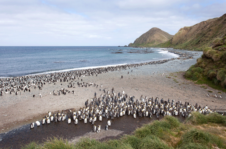
_tbickford_galapagos_of_the_southern_ocean__(5).jpg)
_mkelly_galapagos_of_the_southern_ocean_7_(custom).jpg)
.jpg)
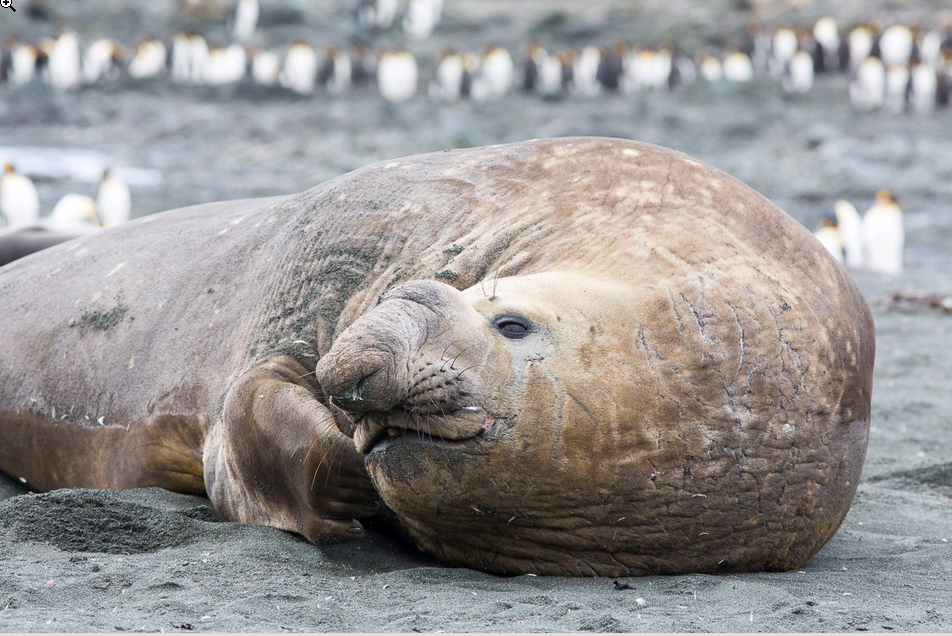
_mkelly_galapagos_of_the_southern_ocean_3_(custom).jpg)